Longer Curfew Hours in Whitfield Town and Waterford to Control Spread of COVID-19
By: , October 7, 2020The Full Story
Special measures targeted at controlling the spread of COVID-19 in the densely populated and highly trafficked communities of Whitfield Town in Kingston and Waterford in St. Catherine have been implemented.
These communities will have longer periods of curfew, reduced gathering limits and strict enforcement of all protocols. Currently, Whitfield Town has 21 active cases and Waterford has 24 active cases.
This was disclosed by Prime Minister, the Most Hon. Andrew Holness, during a Statement in the House of Representatives on October 6, at the Jamaica Conference Centre in downtown Kingston.
Mr. Holness informed that the curfew in these areas will start at 6:00 p.m. today, October 6, to 5:00 a.m. the following day, each day, ending at 5:00 a.m. on October 20, 2020.
“During curfew hours, only essential workers with identification will be allowed to enter or exit. The gathering limit will be no more than six persons in any public place from October 7 to October 19,” Mr. Holness said.
He added that all the other existing restrictions, such as mask wearing and physical distancing will be strictly enforced.
However, the Prime Minister said that in these areas, persons will be allowed to undertake necessary productive activities, such as going to work, take public transport, carry out their essential activities of daily living, such as shopping, visiting the doctor and carrying on their business activities.
He added that these actions will be underpinned by increasing public education and awareness through extensive community engagement.
Kingston & St. Andrew and St. Catherine account for almost 70 per cent of the new cases in September. Outside of St. James, which started to see a rise in the latter half of September, the number of cases in the other parishes depicts slow transmission throughout the month.
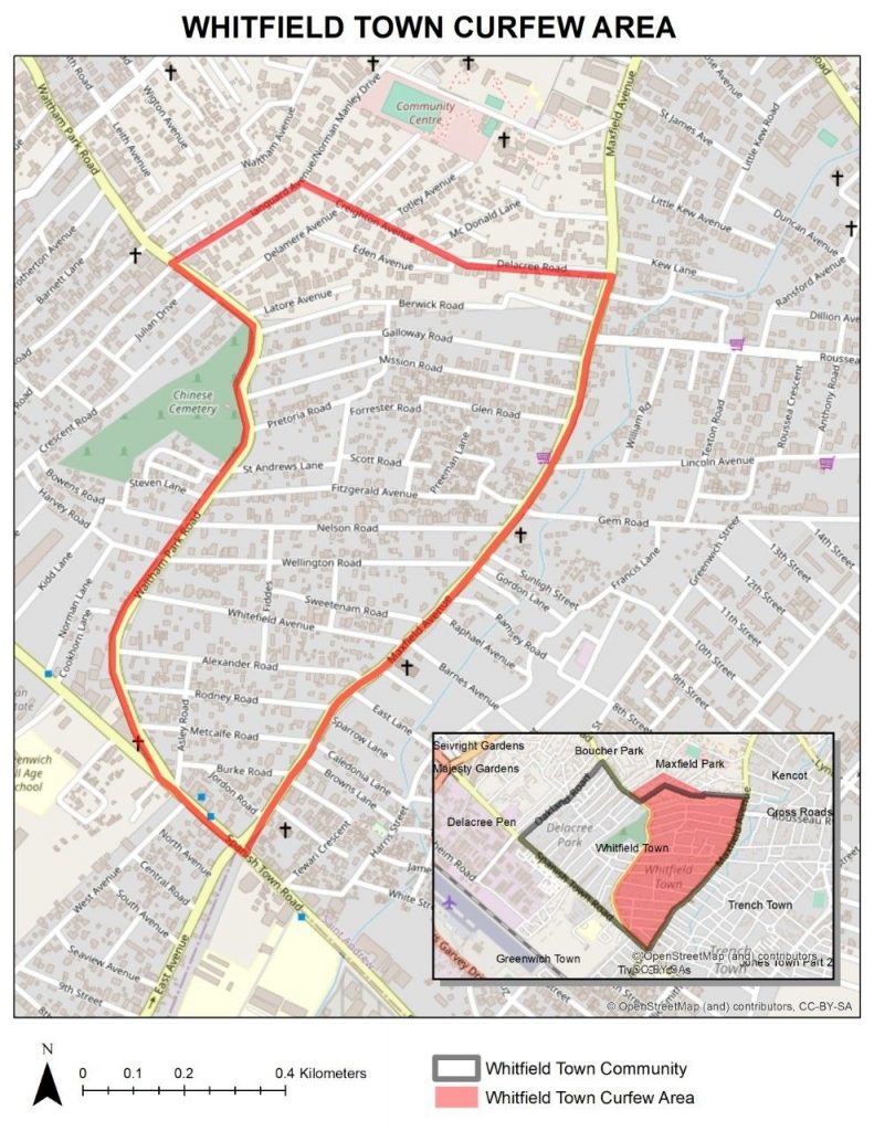
The Whitfield Town curfew area of interest spans approximately 0.7 aq. km and is bounded by a 3.8 km perimeter.

The northern boundary will run from its start point, which is the intersection of Waltham Park Road and Langard Avenue and then continue north-easterly along Langard Avenue to its intersection with Creighton Avenue and then easterly along Creighton Avenue and then on to Delacree Road to its intersection with Maxfield Avenue.
The eastern boundary will start from the intersection of Delacree Road and Maxfield Avenue and will continue in a south-westerly direction along Maxfield Avenue to its intersection with Spanish Town Road.
The southern boundary will start from the intersection of Maxfield Avenue and Spanish Town Road and will continue in a north-westerly direction along Spanish Town Road to its intersection with Waltham Park Road.
The western boundary will start from the intersection of Spanish Town Road and Waltham Park Road and will continue in a northerly direction along Waltham Park Road to the start point at its intersection with Langard Avenue.
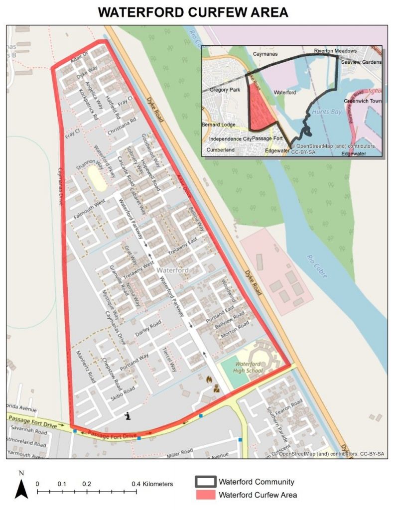
For the Waterford curfew area, the area of interest spans approximately 0.9 sq. km and is bounded by a 4.2 km perimeter.

The northern boundary will run from its start point, which is the intersection of Caymanas Drive and Adair Drive and then continue north-easterly along Adair Drive to the water drain (that runs parallel to Dyke Road).
The eastern boundary will continue along Adair Drive in a south-easterly direction to the perimeter wall of the Waterford High School.
The southern boundary will continue from the Waterford High School in a south-westerly direction along Passage Fort Drive to its intersection with Myrtle Way.
The western boundary will continue from the intersection of Passage Fort Drive and Myrtle Way and will continue due north on to Caymanas Drive to its intersection with Adair Drive.


